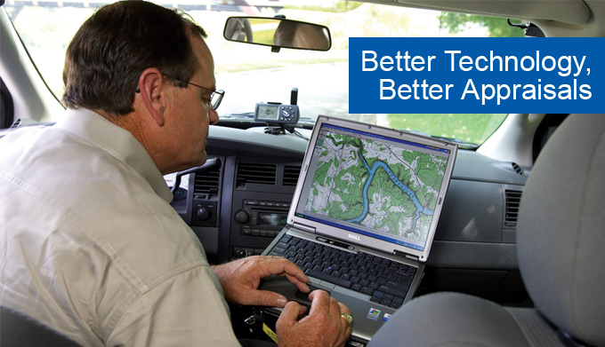
Jon Mask, appraiser for Southwest Texas ACA, locates a property using GPS and a computer in his car.
Photo by Jim Lincoln
Eighty years ago, when the Farm Credit System was in its infancy, a loan officer would often ride horseback around the perimeter of a large farm or ranch to assess the property that his lending cooperative was planning to finance.
Like his Farm Credit predecessors, Jon Mask often finds himself in remote country on his job as an appraiser for Southwest Texas ACA. From the rugged ranchland in the Davis Mountains to South Texas brush pasture, he frequently travels rough roads and overgrown trails that seldom see a pickup or even a horse.
But Mask and his colleagues who appraise rural real estate don't worry about getting lost or breaking down in the field. Thanks to global positioning systems (GPS) in their vehicles these days, Farm Credit appraisers always know their precise locations.
"GPS has changed the way we work more than any other technology that has come along, outside of computers," says the veteran rural real estate appraiser. "With current technology, we can do our jobs quicker, more efficiently and with greater accuracy than ever before."
Gone are the days when Farm Credit appraisers and loan officers carried rolled-up, dog-eared topographic maps in their vehicles. Today, working from their offices or their cars, they use topographic mapping software to locate and delineate properties on their computers, saving time and money, and -- most important -- doing so with precision. If they need to check recent landmarks, they will download satellite images of the property from the Internet.
"You can tell me this is Grandpa's farm, and I can take the legal description of the property from the deed of trust, map it on my computer, and then tell you the acreage. I don't even have to go out there," Mask says.
When the appraiser does visit the property, he will use GPS to verify the property location by establishing longitude and latitude positions and examining features such as buildings, fences and access roads.
"GPS does not replace visual inspections. We inspect every property that we have a loan on," says Mask. "GPS is just another tool that allows us to see things we might not otherwise see."
There are many times when a visual inspection and topographic map alone are insufficient. An example, says Robby Vann, vice president and chief appraiser for the Farm Credit Bank of Texas, is when a property is on the edge of a floodplain. The use of GPS with digital mapping will determine if buildings on the property are in the floodplain and therefore need to be covered by flood insurance.
In another case, Southwest Texas ACA recently worked with two loan applicants who were interested in buying a ranch that had not been surveyed. They planned to divide the land between them and apply for separate loans. Although they knew there was a well on the property, they didn't know where. Mask located the well and then used his GPS to determine on which half of the property it was located.
Some Farm Credit appraisers also use software that allows them to delineate a property on a map on their computer and then overlay it with soil maps and satellite images. "This kind of information helps the lender to do a thorough appraisal more efficiently and to reduce the cost of operations," says Vann.
"There is no doubt about it -- technology is helping appraisers in the Tenth Farm Credit District to provide top-notch service to its customers," he adds.
-Staff